

Last June at the Apple Worldwide Developer Conference (WWDC), Apple made its usual announcements about upcoming changes to its operating systems — iOS, iPadOS, macOS, watchOS, tvOS. Among the changes were some hotly-anticipated upgrades to Apple Maps, the company’s homegrown alternative to Google Maps and other third-party navigation tools. Today we’ll look at the changes that were made to Apple Maps.
More Map Detail
The first and most visible change made to Apple Maps was the inclusion of much more map detail. This had begun in iOS 12 and macOS 10.14, but the 2019 operating system updates brought the improved detail to the entire USA as a preview of what to expect worldwide.
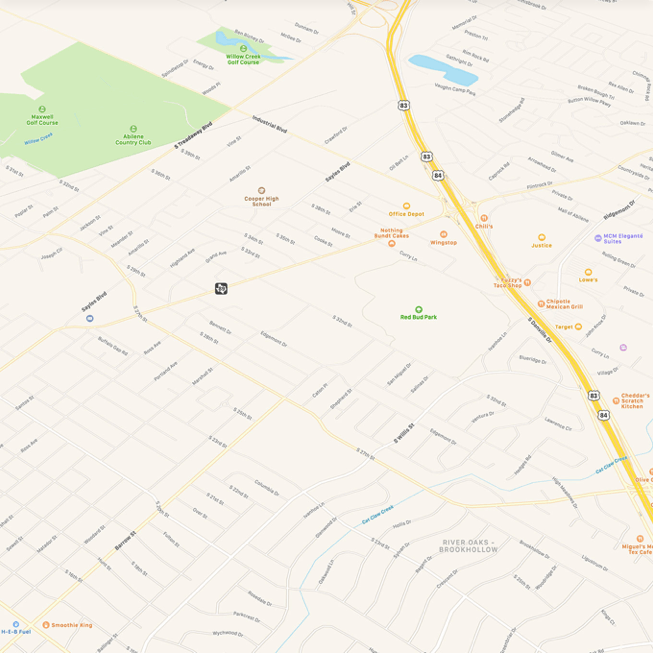
As you can see in the GIF from Apple embedded above, the improvements show outlines of buildings where there used to be white space and more detailed land cover. Where parks previously showed a boundary and a name, detail now abounds with trails, ponds, sports fields, and more visible in the maps. On the golf course, it’s possible to see water hazards, sand traps, and roughs.
The result is a much more accurate set of maps. Instead of just seeing streets marked, one can now see where commercial and residential buildings are located.
Look Around
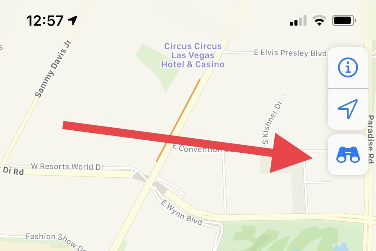
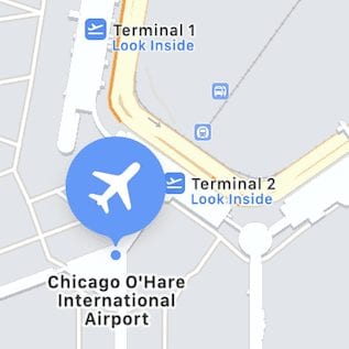
One feature of Google Maps that has always been impressive is Street View, which provides a 360° view from almost any street or road around the world. Look Around adds a similar function to Apple Maps, but at this time, it’s only available in a relative handful of American cities: San Francisco, Los Angeles, Houston, Las Vegas, New York City, Honolulu, Boston, Philadelphia, and Washington, DC.
Sadly, it’s not available on macOS — just iOS and iPadOS. To see where Look Around is enabled, bring up a map on one of the mobile operating systems, zoom in on the map, and then look for a blue binocular icon (see image below).
Click that icon, and a small window opens on the part of the map that shows the Look Around view, while the map shows the location of the 360° view and the direction you’re currently looking (see image below):
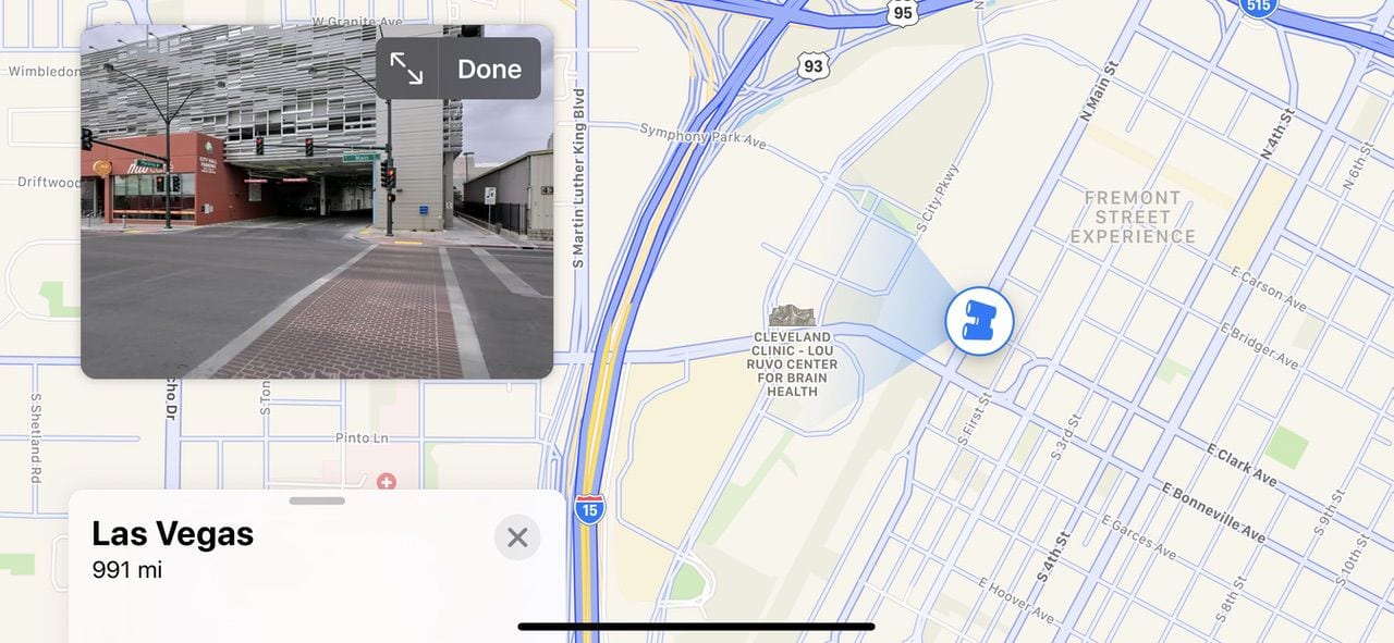
Tap the arrows on the 360° view (next to the word “Done”), and the image expands to fill your screen. With a swipe in any direction, you can look left, right, up, or down. Some facilities such as parking garages and restaurants are marked on the Look Around image with tappable icons for getting more information. On some streets or at intersections, street names float in mid-air in large, readable text.
Apple may not have the entire world covered with 360° views — yet — but the images are much more detailed than those in Google Street View.
Collections
One very useful new feature of Apple Maps is Collections. A Collection is a list of locations that can be created and edited by a user, then shared with a person or group.
Collections have a myriad of uses. For trip planning, it’s possible to capture locations for restaurants, hotels, sightseeing spots, sports arenas, and so on. Do that trip planning ahead of time and share the collection with anyone you’re traveling with, and they can call up all of the pertinent details with a few taps. Once you’re on the trip, navigating to any one of the locations is as simple tapping on the location listing, then tapping a “Directions” button.
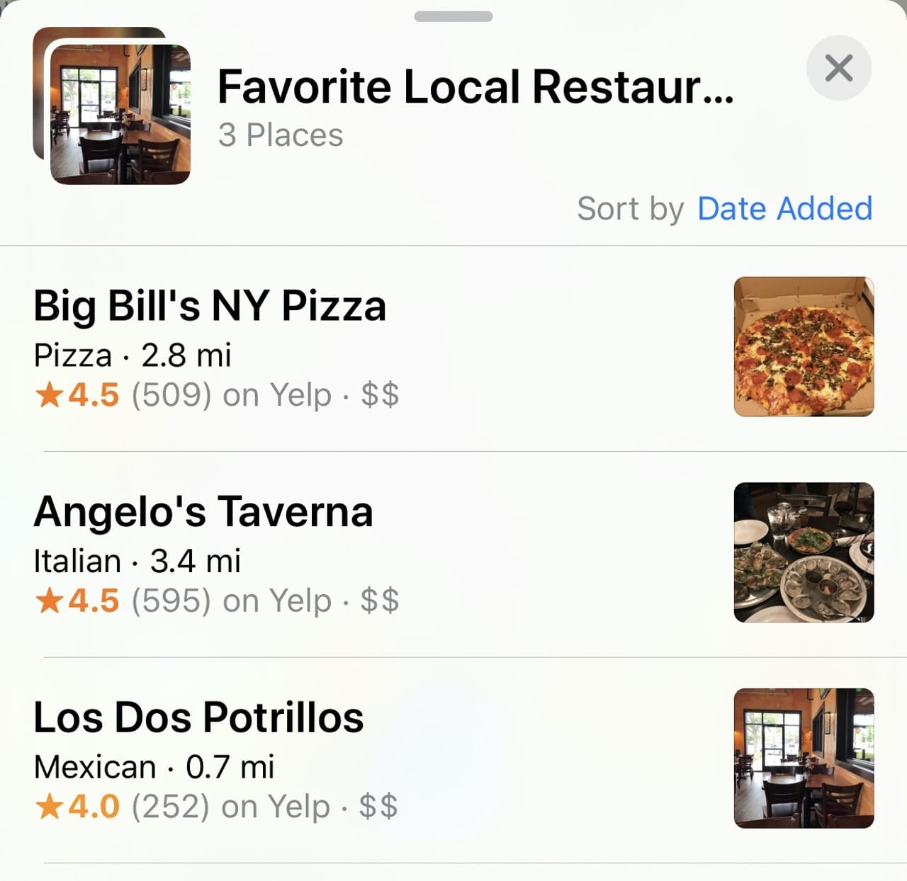
Once again, Collections are only available on Apple’s mobile operating systems. Fortunately, that means that you can create them on iOS and iPadOS, then view them on iPhone, iPad and Apple Watch. macOS is still missing for this feature.
Any Collection created is immediately synced to the appropriate devices logged into the same iCloud account, and Collections can also be shared by email, Message, and AirDrop.
Improved Real-Time Transit Data
Apple also improved the ability to use Maps to help travel from place to place on public transit. This works on macOS, iOS, and iPadOS any time you ask for directions to a location. Simply select the “Transit” option, and Maps calculates the shortest trip time-wise to get you to your destination, including any walking that is required to get to a bus stop or train station.
For many mass transit systems around the globe, the current pandemic is causing reductions in service. Fortunately, Maps advises you of any changes in service with a caution sign that leads to the transit authority’s web page explaining the changes.
While Maps has featured public transit for a while, it is now quite improved over the earlier versions.
Share ETA
Have you ever used Glympse? It’s an app that’s been around for a while on the web and iPhone that allows a user to send his or her location to another person. That location is updated in real-time, along with an estimated time of arrival (ETA).
Well, Glympse no more! The ability to share your current location, route, destination and ETA is now available in the iOS and iPadOS versions of Maps (it’s assumed that you’re not going to be using your Mac for navigation in your car…).

Once you’ve started turn-by-turn directions to a location, a “Share ETA” link appears. Tap on it, select a person to share the information with, and then start on your merry way. The recipient of the shared ETA can view your exact location, your route, and when you’ll get to the destination. The share ends once you’ve reached your destination.
Ridesharing Services
While it’s not new, Apple’s embrace of ridesharing services (well, at least one — Uber) is now evident in the iOS version of Maps. Bring up directions to a location, select the “Ride” button at the bottom of the screen (choices include Drive, Walk, Transit, and Ride), and a list of the various Uber options appears (see image below).
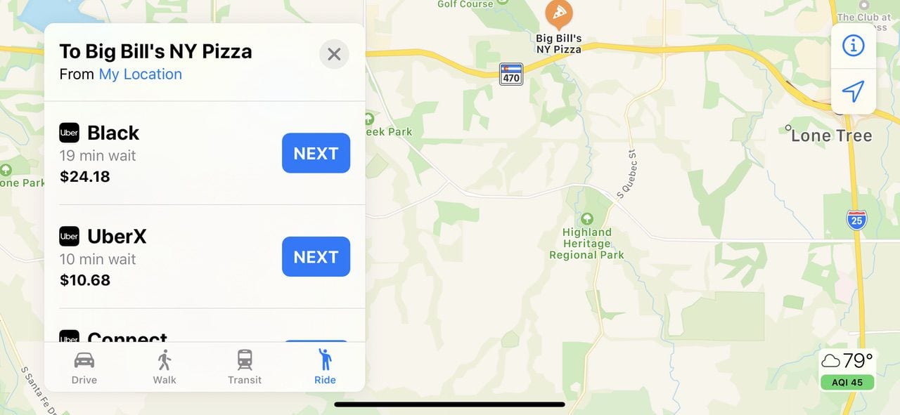
By options, we’re referring to how long it will take for you to be picked up by the Uber driver, what “class” of ride you’ll be getting, and how much the ride will cost you. Lyft used to provide a Maps extension that added its service to the Maps app, but that has disappeared.
In fact, all ridesharing services had disappeared from Maps at one point, but Uber was added back to the iOS app. Since Apple seems unsure of how to handle ridesharing, it’s worth checking to make sure it’s available in Maps before you need it…or just load the apps for Uber and Lyft on your iPhone to make sure you’re covered.
Maps Still Needs Improvement
The Apple Maps apps still need a lot of improvement, although Apple’s changes up to this time show a lot of time and effort has been expended in making it a useful navigation tool. Among changes, we’d like to see include a similar feature set across all platforms, the ability to download maps for offline use (a useful feature in Google Maps), and crowd-sourced accident and police reports similar to those found in Waze.
With all of Apple’s talk about augmented reality (AR), it’s surprising that Look Around isn’t available everywhere. If the company really wants to make Look Around an AR stand out, they’ll also need to get rid of the need to swipe across the screen of a device to see what’s “around” a particular point. It should be sufficient to just move the iPhone or iPad around to get a different view.
On June 22, 2020, we’ll get an idea of the upcoming changes to Maps at WWDC 2020. Perhaps at that time, we’ll see some of these suggestions being acted upon.


You are right, it needs a LOT of improvement.
OMG. More travel down the down of abandoning macOS. I really dislike iOS and I don’t know what to do now that a few (and growing) number of tools are “iOS only” Is the writing on the wall that macOS after v 10.6 (Snow Leopard) is being slowly ignored and the good ol’ days of following “Human Interface Design Guidelines” are fading away.
Perhaps I should return to gardening and just read books, atlases and review paper maps . . .